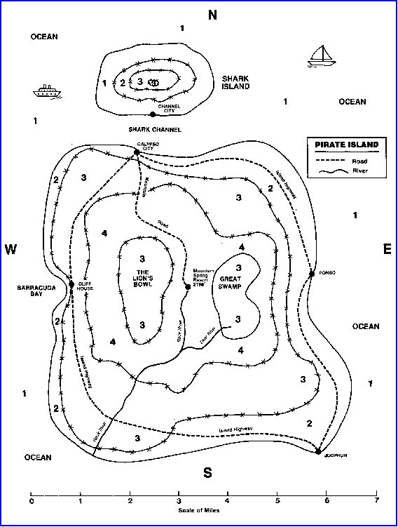
There are several ways to read elevation (the height of a place above the level of the sea) on a map. One way is through the use of colour. This method is useful for giving the general elevation of a place, but it is far from exact. The activity that follows will help you learn to interpret elevation through the use of colour.
- You will need a set of crayons or coloured pencils - blue, green, brown, and red.
- The map next map shows a make - believe island. Some towns and other kinds of places are shown on the map.
- You will see certain numerals within an enclosed space. Follow the key shown below and colour the enclosures. Try not to colour so heavily that the places and names on the map are covered, keep the colour light and evenly toned.
Blue: Sea level or 0': 1
Green: Sea level to 1,000': 2
Brown: Sea level to 2,000': 3
Red: Sea level to 3,000: 4
- The elevation of Ponso is somewhere between sea level and _________ feet.
- Does Island Highway ever climb higher than 1,000' above sea level? _______Yes ______No
- Does Mountain Road climb to an elevation of at least 2,000 feet? _______Yes ______No
- If you were at Mountain Springs Resort and looked directly east, would you probably be able to see the ocean on a clear day? ______Yes ______No
Explain your answer:
- How many feet does Rock River fall before it enters the ocean? ______________________feet.
- Why would it be difficult to land a boat in Barracuda Bay?
- At what elevation does Deer River begin? Between: ________feet and ________feet
- Suppose someone said, "Deer River must flow through a deep gorge." How would you know from studying the map that this is probably true?
- Find Shark Island north of Pirate Island. Colour the enclosures in the same way that you coloured Pirate Island.
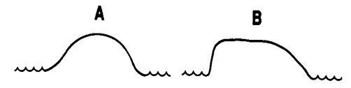
Now imagine that you are looking at Shark Island from Calypso City. Which of the profiles shown below would it most resemble? _______________A __________________B
- How many air miles is it from:
- Cliff House to Ponso? _____________________
- Jodphur to Calypso? _____________________
- Channel City to Cliff House _________________
- Ponso all the way around the island on Island Highway and back to Ponso? Approximately __________miles.